Noisy-le-Roi night lights from space
Night Light of Noisy-le-Roi (Île-de-France) from space (France) Src. Average luminocity for 10x10km area is 65.6932% and for 50x50km: 58.6586%.
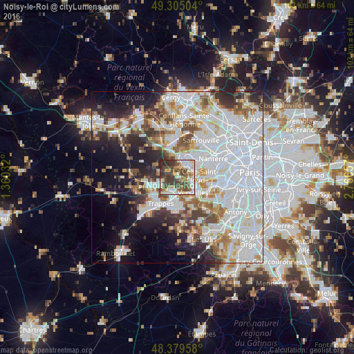
Analysis of Noisy-le-Roi night lights 2016
Square area 10x10 km:
 11.93%
90-99
17.33%80-89
8.38%70-79
6.11%60-69
8.95%50-59
8.24%40-49
20.6%30-39
15.2%20-29
3.27%10-19
0%0-9
0%Square area 50x50 km:
24.14%90-99
14.19%80-89
4.66%70-79
4.53%60-69
5.17%50-59
4.31%40-49
5.36%30-39
4.62%20-29
7.08%10-19
9.99%0-9
15.94%Clear (daylight) street map image can be seen on geolist.org.
Map coordinates:
49° 18' 18.1" North, 1° 21' 37.2" East
48° 50' 40" North, 2° 3' 48.4" East
48° 22' 46.5" North, 2° 45' 59.7" East
Some cities around Noisy-le-Roi sort by population:
• Le Chesnay
5 km =3.1 mi,  119°
119°
• Marly-le-Roi
2.9 km =1.8 mi,  30°
30°
• Saint-Cyr-l’École
5.1 km =3.2 mi,  176°
176°
• Bois-d’Arcy
5.8 km =3.6 mi,  210°
210°
• Fontenay-le-Fleury
3.7 km =2.3 mi,  196°
196°
• Villepreux
5.1 km =3.2 mi,  249°
249°
• Bougival
6 km =3.7 mi,  70°
70°
• Louveciennes
4.2 km =2.6 mi,  63°
63°
2990188 (p: 8,218)
Sources (retrieved 2019-11-25):
» Earth at Night: Flat Maps 2012, 2016