Maule night lights from space
Night Light of Maule (Île-de-France) from space (France) Src. Average luminocity for 10x10km area is 26.0724% and for 50x50km: 34.3631%.
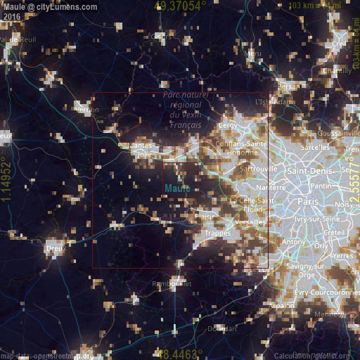
Analysis of Maule night lights 2016
Square area 10x10 km:
 1.42%
1.42%90-99
2.98%80-89
0.71%70-79
1.14%60-69
2.84%50-59
4.12%40-49
5.82%30-39
6.82%20-29
18.04%10-19
44.03%0-9
12.07%Square area 50x50 km:
7.55%90-99
8.33%80-89
3.47%70-79
3.55%60-69
4.1%50-59
3.94%40-49
5.32%30-39
4.36%20-29
7.19%10-19
11.61%0-9
40.58%Clear (daylight) street map image can be seen on geolist.org.
Map coordinates:
49° 22' 13.9" North, 1° 8' 58.3" East
48° 54' 38" North, 1° 51' 9.5" East
48° 26' 46.7" North, 2° 33' 20.8" East
Some cities around Maule sort by population:
• Les Mureaux
9.9 km =6.2 mi,  24°
24°
• Verneuil-sur-Seine
10.8 km =6.7 mi,  49°
49°
• Aubergenville
5.5 km =3.4 mi,  1°
1°
• Beynes
6.2 km =3.9 mi,  166°
166°
• Gargenville
9.1 km =5.7 mi,  340°
340°
• Épône
5.4 km =3.4 mi, 335°
• Orgeval
9.2 km =5.7 mi,  82°
82°
• Villennes-sur-Seine
10.7 km =6.6 mi,  71°
71°
2995110 (p: 6,272)
Sources (retrieved 2019-11-25):
» Earth at Night: Flat Maps 2012, 2016