Épône night lights from space
Night Light of Épône (Île-de-France) from space (France) Src. Average luminocity for 10x10km area is 52.0866% and for 50x50km: 30.3209%.
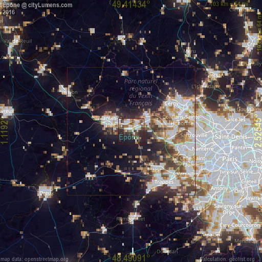
Analysis of Épône night lights 2016
Square area 10x10 km:
 11.51%
90-99
11.65%80-89
3.84%70-79
4.83%60-69
6.68%50-59
7.53%40-49
8.95%30-39
8.95%20-29
18.18%10-19
16.48%0-9
1.42%Square area 50x50 km:
6.32%90-99
7.2%80-89
3.04%70-79
3.11%60-69
3.55%50-59
3.66%40-49
4.86%30-39
4.09%20-29
6.84%10-19
10.3%0-9
47.04%Clear (daylight) street map image can be seen on geolist.org.
Map coordinates:
49° 24' 51.6" North, 1° 7' 9.1" East
48° 57' 17.1" North, 1° 49' 20.4" East
48° 29' 27.3" North, 2° 31' 31.6" East
Some cities around Épône sort by population:
• Mantes-la-Jolie
8.7 km =5.4 mi,  297°
297°
• Les Mureaux
7.6 km =4.7 mi,  57°
57°
• Mantes-la-Ville
9 km =5.6 mi,  283°
283°
• Limay
7.5 km =4.7 mi,  307°
307°
• Aubergenville
2.4 km =1.5 mi,  76°
76°
• Meulan-en-Yvelines
8.5 km =5.3 mi,  46°
46°
• Gargenville
3.8 km =2.4 mi,  348°
348°
• Maule
5.4 km =3.4 mi,  155°
155°
3019985 (p: 6,770)
Sources (retrieved 2019-11-25):
» Earth at Night: Flat Maps 2012, 2016