Magnanville night lights from space
Night Light of Magnanville (Île-de-France) from space (France) Src. Average luminocity for 10x10km area is 44.4844% and for 50x50km: 19.1492%.
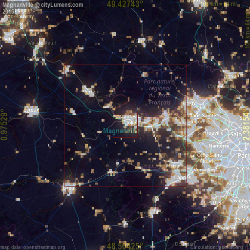
Analysis of Magnanville night lights 2016
Square area 10x10 km:
 10.65%
90-99
11.51%80-89
4.26%70-79
5.82%60-69
2.41%50-59
3.98%40-49
5.82%30-39
4.26%20-29
9.8%10-19
25.43%0-9
16.05%Square area 50x50 km:
2.87%90-99
3.49%80-89
1.71%70-79
2%60-69
2.35%50-59
2.44%40-49
3.39%30-39
2.95%20-29
6.05%10-19
11.24%0-9
61.52%Clear (daylight) street map image can be seen on geolist.org.
Map coordinates:
49° 25' 38.7" North, 0° 58' 31" East
48° 58' 4.7" North, 1° 40' 42.3" East
48° 30' 15.3" North, 2° 22' 53.5" East
Some cities around Magnanville sort by population:
• Mantes-la-Jolie
3.8 km =2.4 mi,  48°
48°
• Les Mureaux
17.1 km =10.6 mi,  81°
81°
• Mantes-la-Ville
1.9 km =1.2 mi,  70°
70°
• Limay
5.5 km =3.4 mi,  56°
56°
• Aubergenville
12.9 km =8 mi,  93°
93°
• Gargenville
10 km =6.2 mi, 77°
• Épône
10.6 km =6.6 mi,  97°
97°
• Maule
14.2 km =8.8 mi,  116°
116°
2996802 (p: 5,539)
Sources (retrieved 2019-11-25):
» Earth at Night: Flat Maps 2012, 2016