Louvres night lights from space
Night Light of Louvres (Île-de-France) from space (France) Src. Average luminocity for 10x10km area is 59.5863% and for 50x50km: 49.9524%.
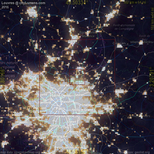
Analysis of Louvres night lights 2016
Square area 10x10 km:
 12.8%
12.8%90-99
14.73%80-89
6.25%70-79
2.53%60-69
6.99%50-59
13.69%40-49
10.57%30-39
16.67%20-29
8.78%10-19
6.99%0-9
0%Square area 50x50 km:
22.54%90-99
10.55%80-89
3.41%70-79
2.85%60-69
3.53%50-59
3.58%40-49
3.33%30-39
4.07%20-29
7.73%10-19
16.35%0-9
22.06%Clear (daylight) street map image can be seen on geolist.org.
Map coordinates:
49° 30' 12" North, 1° 48' 6" East
49° 2' 40.6" North, 2° 30' 17.2" East
48° 34' 53.7" North, 3° 12' 28.5" East
Some cities around Louvres sort by population:
• Villepinte
9.4 km =5.8 mi,  167°
167°
• Goussainville
4.5 km =2.8 mi,  219°
219°
• Villiers-le-Bel
8.7 km =5.4 mi,  242°
242°
• Gonesse
7.6 km =4.7 mi,  212°
212°
• Arnouville
9.4 km =5.8 mi, 223°
• Fosses
6 km =3.7 mi,  3°
3°
• Écouen
9.3 km =5.8 mi,  253°
253°
• Marly-la-Ville
4.2 km =2.6 mi,  358°
358°
2997317 (p: 9,323)
Sources (retrieved 2019-11-25):
» Earth at Night: Flat Maps 2012, 2016