Lambres-lez-Douai night lights from space
Night Light of Lambres-lez-Douai (Hauts-de-France) from space (France) Src. Average luminocity for 10x10km area is 67.4216% and for 50x50km: 37.0275%.
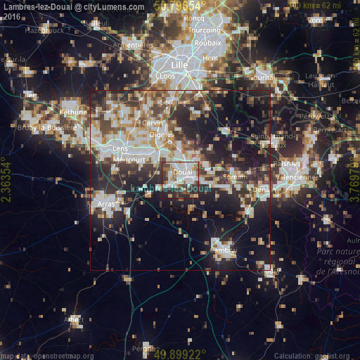
Analysis of Lambres-lez-Douai night lights 2016
Square area 10x10 km:
 21.57%
90-99
20.31%80-89
4.48%70-79
4.34%60-69
7%50-59
6.86%40-49
5.88%30-39
12.75%20-29
14.15%10-19
2.66%0-9
0%Square area 50x50 km:
7.21%90-99
8.38%80-89
3.35%70-79
3.66%60-69
4.77%50-59
4.16%40-49
5.39%30-39
6.17%20-29
11.95%10-19
17.72%0-9
27.23%Clear (daylight) street map image can be seen on geolist.org.
Map coordinates:
50° 47' 47.5" North, 2° 21' 48.7" East
50° 21' 0" North, 3° 4' 0" East
49° 53' 57.2" North, 3° 46' 11.2" East
Some cities around Lambres-lez-Douai sort by population:
• Douai
2.5 km =1.6 mi,  21°
21°
• Sin-le-Noble
4.8 km =3 mi,  74°
74°
• Waziers
5.4 km =3.4 mi,  39°
39°
• Auby
7.2 km =4.5 mi,  352°
352°
• Cuincy
3.4 km =2.1 mi,  343°
343°
• Roost-Warendin
8.1 km =5 mi, 18°
• Flers-en-Escrebieux
5.3 km =3.3 mi,  355°
355°
• Dechy
3.5 km =2.2 mi,  90°
90°
3008198 (p: 5,057)
Sources (retrieved 2019-11-25):
» Earth at Night: Flat Maps 2012, 2016