La Flèche night lights from space
Night Light of La Flèche (Pays de la Loire) from space (France) Src. Average luminocity for 10x10km area is 0.8958% and for 50x50km: 0.907%.
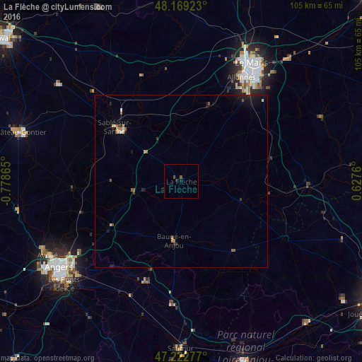
Analysis of La Flèche night lights 2016
Square area 10x10 km:
 0%
0%90-99
0%80-89
0%70-79
0%60-69
0%50-59
0.45%40-49
0.74%30-39
0%20-29
0.6%10-19
0.6%0-9
97.62%Square area 50x50 km:
0.06%90-99
0.08%80-89
0.09%70-79
0.08%60-69
0.19%50-59
0.2%40-49
0.08%30-39
0.13%20-29
0.15%10-19
0.67%0-9
98.29%Clear (daylight) street map image can be seen on geolist.org.
Map coordinates:
48° 10' 9.2" North, 0° 46' 43.1" West
47° 41' 53.3" North, 0° 4' 31.9" West
47° 13' 22" North, 0° 37' 39.4" East
Some cities around La Flèche sort by population:
• Le Mans
39.6 km =24.6 mi,  31°
31°
• Sablé-sur-Sarthe
24.7 km =15.3 mi,  308°
308°
• Allonnes
34.6 km =21.5 mi, 30°
• Jumelles
29.3 km =18.2 mi,  184°
184°
• Juigné
23.9 km =14.9 mi,  275°
275°
• Arnage
32.1 km =19.9 mi,  37°
37°
• Beaufort-en-Vallée
30.7 km =19.1 mi,  200°
200°
• Château-du-Loir
37 km =23 mi,  90°
90°
3009443 (p: 18,536)
Sources (retrieved 2019-11-25):
» Earth at Night: Flat Maps 2012, 2016