Beaufort-en-Vallée night lights from space
Night Light of Beaufort-en-Vallée (Pays de la Loire) from space (France) Src. Average luminocity for 10x10km area is 3.7599% and for 50x50km: 2.5862%.
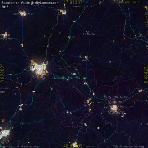
Analysis of Beaufort-en-Vallée night lights 2016
Square area 10x10 km:
 0%
0%90-99
0%80-89
0.28%70-79
1.42%60-69
0.57%50-59
0.57%40-49
1.14%30-39
1.14%20-29
1.56%10-19
0.14%0-9
93.18%Square area 50x50 km:
0.34%90-99
0.39%80-89
0.32%70-79
0.41%60-69
0.28%50-59
0.27%40-49
0.46%30-39
0.28%20-29
0.82%10-19
1.56%0-9
94.88%Clear (daylight) street map image can be seen on geolist.org.
Map coordinates:
47° 54' 47.1" North, 0° 55' 19.3" West
47° 26' 22.7" North, 0° 13' 8" West
46° 57' 42.9" North, 0° 29' 3.2" East
Some cities around Beaufort-en-Vallée sort by population:
• Angers
25 km =15.5 mi,  278°
278°
• Saumur
22.7 km =14.1 mi,  152°
152°
• Avrillé
28.2 km =17.5 mi, 283°
• Les Ponts-de-Cé
23.1 km =14.4 mi,  265°
265°
• Trélazé
18.5 km =11.5 mi, 272°
• Doué-la-Fontaine
27.7 km =17.2 mi,  188°
188°
• Jumelles
8.7 km =5.4 mi,  93°
93°
• Mûrs-Erigné
25.3 km =15.7 mi,  259°
259°
3034309 (p: 5,677)
Sources (retrieved 2019-11-25):
» Earth at Night: Flat Maps 2012, 2016