La Tour-du-Pin night lights from space
Night Light of La Tour-du-Pin (Auvergne-Rhône-Alpes) from space (France) Src. Average luminocity for 10x10km area is 19.3636% and for 50x50km: 10.479%.
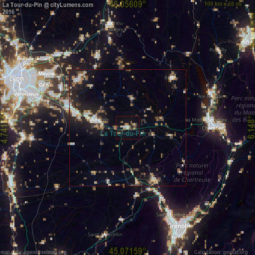
Analysis of La Tour-du-Pin night lights 2016
Square area 10x10 km:
 1.36%
1.36%90-99
1.97%80-89
3.03%70-79
2.27%60-69
3.48%50-59
2.88%40-49
1.36%30-39
3.94%20-29
2.73%10-19
15%0-9
61.97%Square area 50x50 km:
1.01%90-99
1.36%80-89
0.89%70-79
1%60-69
1.41%50-59
1.74%40-49
1.38%30-39
2.19%20-29
3.74%10-19
7.31%0-9
77.96%Clear (daylight) street map image can be seen on geolist.org.
Map coordinates:
46° 3' 21.9" North, 4° 44' 30.3" East
45° 33' 57.6" North, 5° 26' 41.5" East
45° 4' 17.7" North, 6° 8' 52.8" East
Some cities around La Tour-du-Pin sort by population:
• Bourgoin-Jallieu
13.5 km =8.4 mi,  279°
279°
• Voiron
24.9 km =15.5 mi,  153°
153°
• Villefontaine
23.5 km =14.6 mi, 282°
• L’Isle-d’Abeau
18.1 km =11.2 mi,  289°
289°
• Moirans
27.4 km =17 mi,  161°
161°
• Saint-Quentin-Fallavier
27.2 km =16.9 mi, 288°
• La Verpillière
24.5 km =15.2 mi, 288°
• Rives
24.1 km =15 mi,  169°
169°
3006202 (p: 7,248)
Sources (retrieved 2019-11-25):
» Earth at Night: Flat Maps 2012, 2016