Floirac night lights from space
Night Light of Floirac (Nouvelle-Aquitaine) from space (France) Src. Average luminocity for 10x10km area is 78.9841% and for 50x50km: 27.9991%.
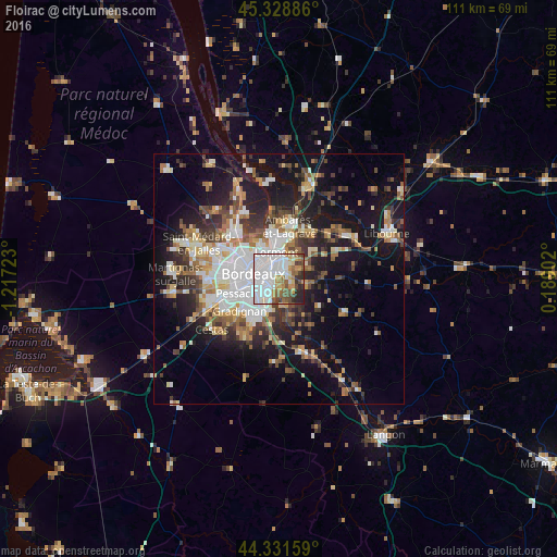
Analysis of Floirac night lights 2016
Square area 10x10 km:
 38.25%
90-99
16.19%80-89
4.92%70-79
8.41%60-69
5.56%50-59
8.73%40-49
7.3%30-39
3.49%20-29
6.51%10-19
0.63%0-9
0%Square area 50x50 km:
6.05%90-99
5.02%80-89
2.85%70-79
2.75%60-69
3.86%50-59
3.49%40-49
3.86%30-39
3.89%20-29
6.4%10-19
16.31%0-9
45.52%Clear (daylight) street map image can be seen on geolist.org.
Map coordinates:
45° 19' 43.9" North, 1° 13' 2" West
44° 49' 56.6" North, 0° 30' 50.8" West
44° 19' 53.7" North, 0° 11' 20.5" East
Some cities around Floirac sort by population:
• Bordeaux
5.3 km =3.3 mi,  279°
279°
• Talence
7.1 km =4.4 mi,  244°
244°
• Villenave-d’Ornon
7 km =4.3 mi,  199°
199°
• Bègles
3.8 km =2.4 mi,  225°
225°
• Lormont
4.7 km =2.9 mi,  356°
356°
• Cenon
2.6 km =1.6 mi,  352°
352°
• Carbon-Blanc
7.2 km =4.5 mi,  8°
8°
• Artigues-près-Bordeaux
2 km =1.2 mi, 354°
3018246 (p: 16,497)
Sources (retrieved 2019-11-25):
» Earth at Night: Flat Maps 2012, 2016