Delle night lights from space
Night Light of Delle (Bourgogne-Franche-Comté) from space (France) Src. Average luminocity for 10x10km area is 17.6548% and for 50x50km: 12.8171%.
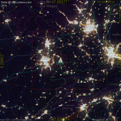
Analysis of Delle night lights 2016
Square area 10x10 km:
 1.99%
1.99%90-99
2.98%80-89
2.56%70-79
2.13%60-69
1.14%50-59
0.99%40-49
1.42%30-39
1.99%20-29
0.57%10-19
30.26%0-9
53.98%Square area 50x50 km:
1.8%90-99
2.11%80-89
1.09%70-79
0.94%60-69
1.1%50-59
1.73%40-49
2.08%30-39
2.32%20-29
5.03%10-19
9.26%0-9
72.54%Clear (daylight) street map image can be seen on geolist.org.
Map coordinates:
47° 58' 50.8" North, 6° 17' 47.9" East
47° 30' 28.7" North, 6° 59' 59.1" East
47° 1' 51.1" North, 7° 42' 10.4" East
Some cities around Delle sort by population:
• Montbéliard
15.1 km =9.4 mi,  270°
270°
• Audincourt
11.3 km =7 mi,  255°
255°
• Valentigney
13.5 km =8.4 mi,  248°
248°
• Bethoncourt
14.9 km =9.3 mi,  281°
281°
• Porrentruy, CH
11.6 km =7.2 mi,  150°
150°
• Seloncourt
12.1 km =7.5 mi,  243°
243°
• Beaucourt
6.2 km =3.9 mi, 249°
• Grand-Charmont
13.2 km =8.2 mi, 279°
3021629 (p: 6,186)
Sources (retrieved 2019-11-25):
» Earth at Night: Flat Maps 2012, 2016