Valentigney night lights from space
Night Light of Valentigney (Bourgogne-Franche-Comté) from space (France) Src. Average luminocity for 10x10km area is 51.9702% and for 50x50km: 10.3435%.
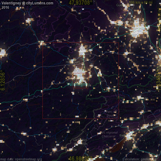
Analysis of Valentigney night lights 2016
Square area 10x10 km:
 13.92%
90-99
13.07%80-89
5.82%70-79
1.99%60-69
2.7%50-59
4.97%40-49
9.09%30-39
8.52%20-29
19.46%10-19
19.03%0-9
1.42%Square area 50x50 km:
1.67%90-99
1.85%80-89
0.95%70-79
0.69%60-69
0.89%50-59
1.23%40-49
1.72%30-39
1.83%20-29
4.32%10-19
6.68%0-9
78.15%Clear (daylight) street map image can be seen on geolist.org.
Map coordinates:
47° 56' 13.5" North, 6° 7' 42.8" East
47° 27' 50" North, 6° 49' 54" East
46° 59' 11" North, 7° 32' 5.3" East
Some cities around Valentigney sort by population:
• Montbéliard
5.7 km =3.5 mi,  333°
333°
• Audincourt
2.7 km =1.7 mi,  37°
37°
• Héricourt
13.2 km =8.2 mi,  336°
336°
• Bethoncourt
8.2 km =5.1 mi,  345°
345°
• Seloncourt
1.8 km =1.1 mi,  104°
104°
• Beaucourt
7.3 km =4.5 mi,  67°
67°
• Mandeure
2.4 km =1.5 mi,  227°
227°
• Grand-Charmont
7 km =4.3 mi,  356°
356°
2971030 (p: 12,608)
Sources (retrieved 2019-11-25):
» Earth at Night: Flat Maps 2012, 2016