Porrentruy night lights from space
Night Light of Porrentruy (Jura) from space (Switzerland) Src. Average luminocity for 10x10km area is 10.0781% and for 50x50km: 12.2961%.
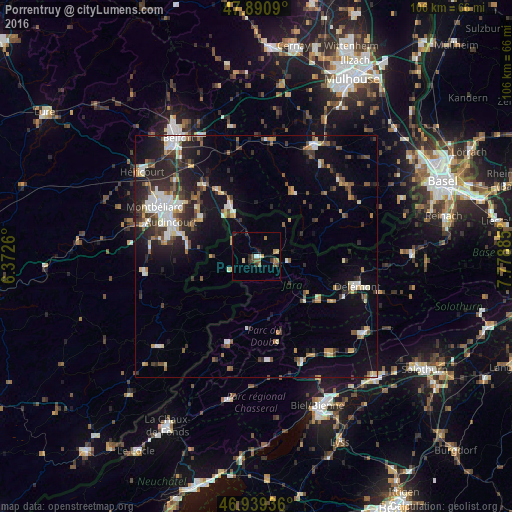
Analysis of Porrentruy night lights 2016
Square area 10x10 km:
 0.28%
0.28%90-99
0.85%80-89
1.14%70-79
0.85%60-69
3.13%50-59
1.99%40-49
1.7%30-39
1.56%20-29
1.85%10-19
1.14%0-9
85.51%Square area 50x50 km:
1.7%90-99
2.05%80-89
1.18%70-79
1.09%60-69
1.13%50-59
1.79%40-49
1.75%30-39
2.04%20-29
4.16%10-19
7.26%0-9
75.84%Clear (daylight) street map image can be seen on geolist.org.
Map coordinates:
47° 53' 27.2" North, 6° 22' 21.4" East
47° 25' 2.2" North, 7° 4' 32.6" East
46° 56' 21.7" North, 7° 46' 43.9" East
Some cities around Porrentruy sort by population:
• Audincourt, FR
18.3 km =11.4 mi,  293°
293°
• Valentigney, FR
19.1 km =11.9 mi, 285°
• Delémont
21.1 km =13.1 mi,  106°
106°
• Delle, FR
11.6 km =7.2 mi,  330°
330°
• Seloncourt, FR
17.2 km =10.7 mi, 285°
• Beaucourt, FR
14 km =8.7 mi,  304°
304°
• Mandeure, FR
20.5 km =12.7 mi,  279°
279°
• Grand-Charmont, FR
22.4 km =13.9 mi, 302°
2659171 (p: 6,521)
Sources (retrieved 2019-11-25):
» Earth at Night: Flat Maps 2012, 2016