Seloncourt night lights from space
Night Light of Seloncourt (Bourgogne-Franche-Comté) from space (France) Src. Average luminocity for 10x10km area is 45.2912% and for 50x50km: 10.3595%.
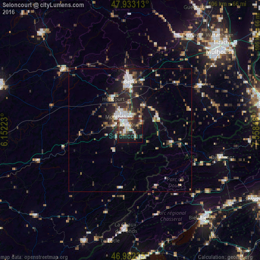
Analysis of Seloncourt night lights 2016
Square area 10x10 km:
 10.37%
90-99
10.65%80-89
4.69%70-79
2.98%60-69
3.27%50-59
3.84%40-49
9.66%30-39
6.53%20-29
16.05%10-19
24.15%0-9
7.81%Square area 50x50 km:
1.68%90-99
1.86%80-89
0.94%70-79
0.72%60-69
0.87%50-59
1.26%40-49
1.7%30-39
1.79%20-29
4.26%10-19
6.58%0-9
78.34%Clear (daylight) street map image can be seen on geolist.org.
Map coordinates:
47° 55' 59.3" North, 6° 9' 8" East
47° 27' 35.6" North, 6° 51' 19.3" East
46° 58' 56.5" North, 7° 33' 30.5" East
Some cities around Seloncourt sort by population:
• Montbéliard
7 km =4.3 mi,  322°
322°
• Audincourt
2.6 km =1.6 mi,  356°
356°
• Valentigney
1.8 km =1.1 mi,  284°
284°
• Bethoncourt
9.2 km =5.7 mi,  335°
335°
• Delle
12.1 km =7.5 mi,  63°
63°
• Beaucourt
6 km =3.7 mi, 57°
• Mandeure
3.8 km =2.4 mi,  251°
251°
• Grand-Charmont
7.8 km =4.8 mi, 343°
2975204 (p: 6,046)
Sources (retrieved 2019-11-25):
» Earth at Night: Flat Maps 2012, 2016