Crozon night lights from space
Night Light of Crozon (Brittany) from space (France) Src. Average luminocity for 10x10km area is 8.9271% and for 50x50km: 4.9124%.
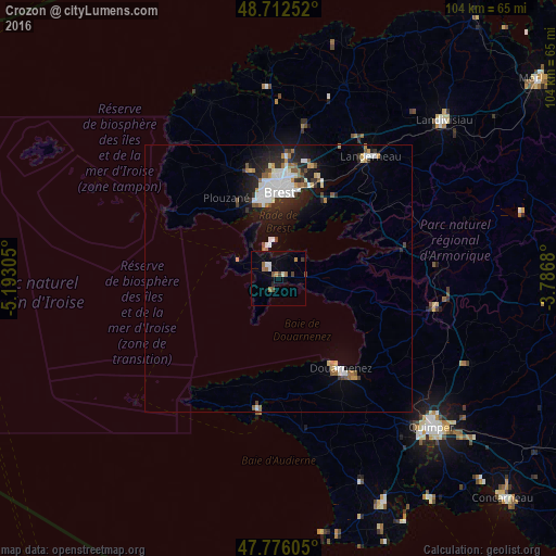
Analysis of Crozon night lights 2016
Square area 10x10 km:
 1.04%
1.04%90-99
1.34%80-89
0%70-79
1.19%60-69
2.83%50-59
1.04%40-49
1.49%30-39
0.6%20-29
0.6%10-19
0.3%0-9
89.58%Square area 50x50 km:
0.98%90-99
1.13%80-89
0.22%70-79
0.37%60-69
0.63%50-59
0.53%40-49
0.41%30-39
0.46%20-29
1.51%10-19
3.05%0-9
90.7%Clear (daylight) street map image can be seen on geolist.org.
Map coordinates:
48° 42' 45.1" North, 5° 11' 35" West
48° 14' 47.1" North, 4° 29' 23.7" West
47° 46' 33.8" North, 3° 47' 12.5" West
Some cities around Crozon sort by population:
• Brest
16 km =9.9 mi,  0°
0°
• Douarnenez
20.6 km =12.8 mi,  144°
144°
• Guipavas
22.1 km =13.7 mi,  18°
18°
• Plougastel-Daoulas
16.2 km =10.1 mi,  34°
34°
• Plouzané
17.9 km =11.1 mi,  328°
328°
• Le Relecq-Kerhuon
19.2 km =11.9 mi, 21°
• Rd pt des Chataigniers, Rte de Milizac, Guilers, Finistère, France
21.6 km =13.4 mi,  344°
344°
• Guilers
20.5 km =12.7 mi,  345°
345°
3022242 (p: 8,123)
Sources (retrieved 2019-11-25):
» Earth at Night: Flat Maps 2012, 2016