Douarnenez night lights from space
Night Light of Douarnenez (Brittany) from space (France) Src. Average luminocity for 10x10km area is 12.314% and for 50x50km: 3.4755%.
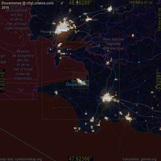
Analysis of Douarnenez night lights 2016
Square area 10x10 km:
 1.64%
1.64%90-99
1.93%80-89
1.64%70-79
1.34%60-69
2.68%50-59
1.79%40-49
0.89%30-39
1.19%20-29
0%10-19
0.74%0-9
86.16%Square area 50x50 km:
0.41%90-99
0.62%80-89
0.36%70-79
0.29%60-69
0.52%50-59
0.48%40-49
0.46%30-39
0.31%20-29
0.43%10-19
2.26%0-9
93.86%Clear (daylight) street map image can be seen on geolist.org.
Map coordinates:
48° 33' 46.4" North, 5° 1' 55.8" West
48° 5' 43.5" North, 4° 19' 44.5" West
47° 37' 25.2" North, 3° 37' 33.3" West
Some cities around Douarnenez sort by population:
• Quimper
20.1 km =12.5 mi,  121°
121°
• Plougastel-Daoulas
30.3 km =18.8 mi,  354°
354°
• Fouesnant
32.5 km =20.2 mi,  134°
134°
• Crozon
20.6 km =12.8 mi,  324°
324°
• Ergué-Gabéric
25.4 km =15.8 mi, 115°
• Pont-l’Abbé
26.8 km =16.7 mi,  161°
161°
• Châteaulin
21 km =13 mi,  57°
57°
• Plonéour-Lanvern
22 km =13.7 mi,  171°
171°
3020996 (p: 16,590)
Sources (retrieved 2019-11-25):
» Earth at Night: Flat Maps 2012, 2016