Le Relecq-Kerhuon night lights from space
Night Light of Le Relecq-Kerhuon (Brittany) from space (France) Src. Average luminocity for 10x10km area is 25.331% and for 50x50km: 5.231%.
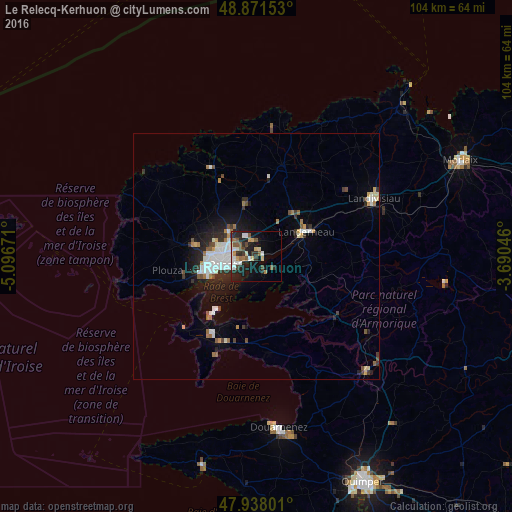
Analysis of Le Relecq-Kerhuon night lights 2016
Square area 10x10 km:
 4.12%
4.12%90-99
3.69%80-89
2.98%70-79
1.99%60-69
2.98%50-59
4.83%40-49
3.13%30-39
2.13%20-29
11.79%10-19
19.32%0-9
43.04%Square area 50x50 km:
0.98%90-99
1.15%80-89
0.3%70-79
0.39%60-69
0.62%50-59
0.53%40-49
0.51%30-39
0.63%20-29
1.66%10-19
3.17%0-9
90.04%Clear (daylight) street map image can be seen on geolist.org.
Map coordinates:
48° 52' 17.5" North, 5° 5' 48.2" West
48° 24' 24.9" North, 4° 23' 36.9" West
47° 56' 16.8" North, 3° 41' 25.7" West
Some cities around Le Relecq-Kerhuon sort by population:
• Brest
7.1 km =4.4 mi,  254°
254°
• Landerneau
11.6 km =7.2 mi,  64°
64°
• Guipavas
3.2 km =2 mi,  355°
355°
• Plougastel-Daoulas
4.9 km =3 mi,  156°
156°
• Rd pt des Chataigniers, Rte de Milizac, Guilers, Finistère, France
13.2 km =8.2 mi,  283°
283°
• Plabennec
10.9 km =6.8 mi,  347°
347°
• Guilers
12.3 km =7.6 mi, 279°
• Gouesnou
7.3 km =4.5 mi,  314°
314°
3002373 (p: 11,911)
Sources (retrieved 2019-11-25):
» Earth at Night: Flat Maps 2012, 2016