Châteaurenard night lights from space
Night Light of Châteaurenard (Provence-Alpes-Côte d'Azur) from space (France) Src. Average luminocity for 10x10km area is 44.273% and for 50x50km: 22.5883%.
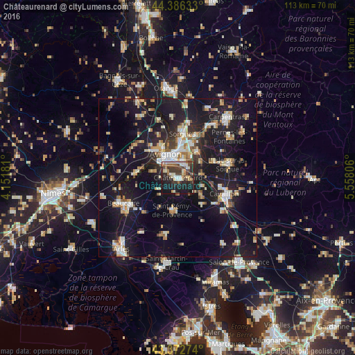
Analysis of Châteaurenard night lights 2016
Square area 10x10 km:
 6.67%
6.67%90-99
9.05%80-89
4.29%70-79
3.97%60-69
5.56%50-59
5.24%40-49
7.3%30-39
14.13%20-29
15.24%10-19
27.46%0-9
1.11%Square area 50x50 km:
2.66%90-99
4.01%80-89
2.88%70-79
2.64%60-69
2.47%50-59
2.06%40-49
2.4%30-39
2.36%20-29
5.68%10-19
28.59%0-9
44.26%Clear (daylight) street map image can be seen on geolist.org.
Map coordinates:
44° 23' 10.8" North, 4° 9' 6.5" East
43° 52' 54.1" North, 4° 51' 17.7" East
43° 22' 21.9" North, 5° 33' 29" East
Some cities around Châteaurenard sort by population:
• Avignon
8.3 km =5.2 mi,  333°
333°
• Le Pontet
8.8 km =5.5 mi,  2°
2°
• Montfavet
5.9 km =3.7 mi,  14°
14°
• Villeneuve-lès-Avignon
10.7 km =6.6 mi, 334°
• Saint-Rémy-de-Provence
10.5 km =6.5 mi,  190°
190°
• Vedène
11.4 km =7.1 mi,  20°
20°
• Les Angles
11.2 km =7 mi,  319°
319°
• Morières-lès-Avignon
7.5 km =4.7 mi,  29°
29°
3026211 (p: 14,205)
Sources (retrieved 2019-11-25):
» Earth at Night: Flat Maps 2012, 2016