Saint-Rémy-de-Provence night lights from space
Night Light of Saint-Rémy-de-Provence (Provence-Alpes-Côte d'Azur) from space (France) Src. Average luminocity for 10x10km area is 11.6833% and for 50x50km: 21.4891%.
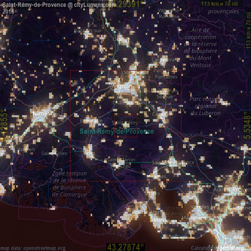
Analysis of Saint-Rémy-de-Provence night lights 2016
Square area 10x10 km:
 0.76%
0.76%90-99
1.06%80-89
1.52%70-79
1.97%60-69
1.67%50-59
0.61%40-49
1.82%30-39
0%20-29
0.15%10-19
7.42%0-9
83.03%Square area 50x50 km:
2.83%90-99
4.05%80-89
2.52%70-79
2.4%60-69
2.35%50-59
2.09%40-49
2.34%30-39
2.24%20-29
5.51%10-19
23.11%0-9
50.57%Clear (daylight) street map image can be seen on geolist.org.
Map coordinates:
44° 17' 38.1" North, 4° 7' 42.8" East
43° 47' 18.5" North, 4° 49' 54" East
43° 16' 43.5" North, 5° 32' 5.3" East
Some cities around Saint-Rémy-de-Provence sort by population:
• Avignon
17.9 km =11.1 mi,  354°
354°
• Cavaillon
17.1 km =10.6 mi,  73°
73°
• Beaucaire
15.2 km =9.4 mi,  278°
278°
• Tarascon
13.9 km =8.6 mi, 277°
• Châteaurenard
10.5 km =6.5 mi,  10°
10°
• Montfavet
16.5 km =10.3 mi, 11°
• Morières-lès-Avignon
17.8 km =11.1 mi,  18°
18°
• Eyguières
19.1 km =11.9 mi,  123°
123°
2977214 (p: 10,562)
Sources (retrieved 2019-11-25):
» Earth at Night: Flat Maps 2012, 2016