Morières-lès-Avignon night lights from space
Night Light of Morières-lès-Avignon (Provence-Alpes-Côte d'Azur) from space (France) Src. Average luminocity for 10x10km area is 59.4286% and for 50x50km: 22.8659%.
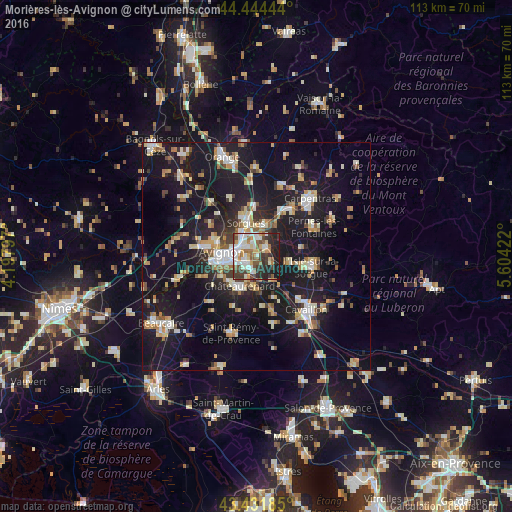
Analysis of Morières-lès-Avignon night lights 2016
Square area 10x10 km:
 14.29%
90-99
15.4%80-89
4.6%70-79
6.03%60-69
6.67%50-59
10.48%40-49
5.71%30-39
12.38%20-29
14.13%10-19
10.32%0-9
0%Square area 50x50 km:
2.73%90-99
4.12%80-89
2.77%70-79
2.68%60-69
2.72%50-59
2.21%40-49
2.33%30-39
2.46%20-29
5.79%10-19
29.3%0-9
42.88%Clear (daylight) street map image can be seen on geolist.org.
Map coordinates:
44° 26' 40" North, 4° 11' 52.7" East
43° 56' 25.1" North, 4° 54' 4" East
43° 25' 54.7" North, 5° 36' 15.2" East
Some cities around Morières-lès-Avignon sort by population:
• Avignon
7.4 km =4.6 mi,  276°
276°
• Sorgues
8.1 km =5 mi,  344°
344°
• Le Pontet
4 km =2.5 mi,  305°
305°
• Châteaurenard
7.5 km =4.7 mi,  209°
209°
• Montfavet
2.3 km =1.4 mi,  250°
250°
• Vedène
4.1 km =2.5 mi,  3°
3°
• Entraigues-sur-la-Sorgue
7.3 km =4.5 mi,  16°
16°
• Le Thor
7.6 km =4.7 mi,  99°
99°
2991799 (p: 7,001)
Sources (retrieved 2019-11-25):
» Earth at Night: Flat Maps 2012, 2016