Villeneuve-lès-Avignon night lights from space
Night Light of Villeneuve-lès-Avignon (Occitanie) from space (France) Src. Average luminocity for 10x10km area is 58.3111% and for 50x50km: 23.7232%.
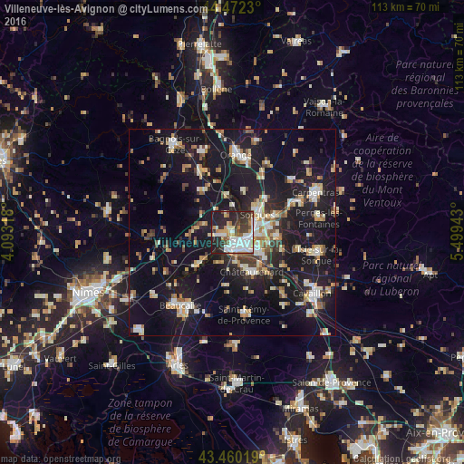
Analysis of Villeneuve-lès-Avignon night lights 2016
Square area 10x10 km:
 16.98%
90-99
15.24%80-89
4.29%70-79
6.51%60-69
3.81%50-59
4.6%40-49
6.51%30-39
8.89%20-29
21.9%10-19
11.27%0-9
0%Square area 50x50 km:
2.83%90-99
4.25%80-89
2.74%70-79
2.65%60-69
2.83%50-59
2.35%40-49
2.64%30-39
2.59%20-29
5.78%10-19
31.2%0-9
40.16%Clear (daylight) street map image can be seen on geolist.org.
Map coordinates:
44° 28' 20.3" North, 4° 5' 35.4" East
43° 58' 6.2" North, 4° 47' 46.7" East
43° 27' 36.7" North, 5° 29' 57.9" East
Some cities around Villeneuve-lès-Avignon sort by population:
• Avignon
2.4 km =1.5 mi,  155°
155°
• Sorgues
7.8 km =4.8 mi,  53°
53°
• Le Pontet
5.2 km =3.2 mi,  98°
98°
• Montfavet
7.3 km =4.5 mi,  122°
122°
• Vedène
8.7 km =5.4 mi,  83°
83°
• Les Angles
2.9 km =1.8 mi,  246°
246°
• Morières-lès-Avignon
9 km =5.6 mi,  110°
110°
• Rochefort-du-Gard
8.5 km =5.3 mi,  276°
276°
2968545 (p: 13,451)
Sources (retrieved 2019-11-25):
» Earth at Night: Flat Maps 2012, 2016