Châteaulin night lights from space
Night Light of Châteaulin (Brittany) from space (France) Src. Average luminocity for 10x10km area is 4.128% and for 50x50km: 2.7421%.
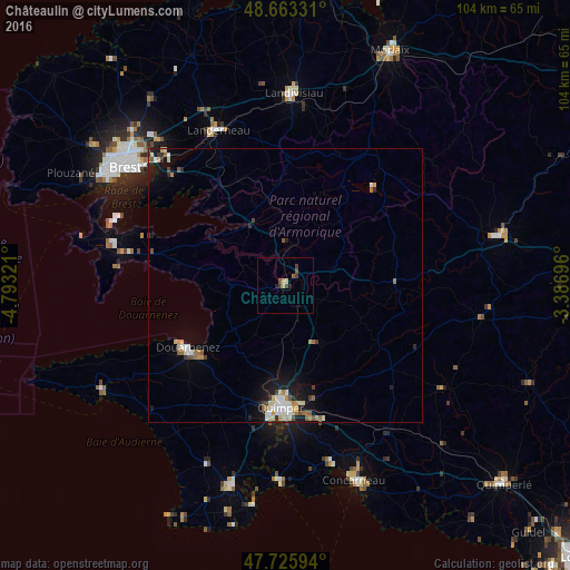
Analysis of Châteaulin night lights 2016
Square area 10x10 km:
 0%
0%90-99
0%80-89
1.34%70-79
0.45%60-69
0%50-59
1.49%40-49
0.6%30-39
2.08%20-29
0.89%10-19
0.3%0-9
92.86%Square area 50x50 km:
0.3%90-99
0.51%80-89
0.45%70-79
0.25%60-69
0.38%50-59
0.37%40-49
0.27%30-39
0.32%20-29
0.4%10-19
1.75%0-9
95%Clear (daylight) street map image can be seen on geolist.org.
Map coordinates:
48° 39' 47.9" North, 4° 47' 35.6" West
48° 11' 48.4" North, 4° 5' 24.3" West
47° 43' 33.4" North, 3° 23' 13.1" West
Some cities around Châteaulin sort by population:
• Quimper
21.9 km =13.6 mi,  181°
181°
• Douarnenez
21 km =13 mi,  237°
237°
• Landerneau
30.9 km =19.2 mi,  337°
337°
• Plougastel-Daoulas
27.9 km =17.3 mi,  312°
312°
• Le Relecq-Kerhuon
32.4 km =20.1 mi,  316°
316°
• Crozon
30.1 km =18.7 mi,  280°
280°
• Ergué-Gabéric
22.9 km =14.2 mi,  167°
167°
• Rosporden
31.9 km =19.8 mi,  143°
143°
3026262 (p: 5,379)
Sources (retrieved 2019-11-25):
» Earth at Night: Flat Maps 2012, 2016