Ingré night lights from space
Night Light of Ingré (Centre) from space (France) Src. Average luminocity for 10x10km area is 57.7088% and for 50x50km: 9.4469%.
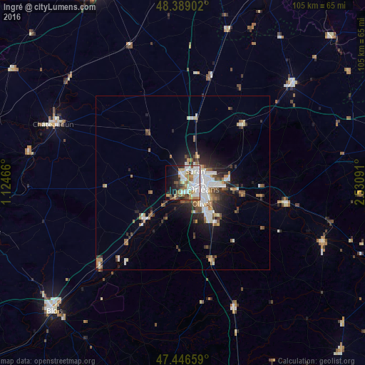
Analysis of Ingré night lights 2016
Square area 10x10 km:
 15.63%
90-99
18.32%80-89
3.13%70-79
7.24%60-69
7.39%50-59
6.68%40-49
4.4%30-39
3.98%20-29
7.1%10-19
13.92%0-9
12.22%Square area 50x50 km:
1.89%90-99
2.17%80-89
0.55%70-79
0.88%60-69
1.09%50-59
1.3%40-49
1.13%30-39
1.26%20-29
2.39%10-19
4.32%0-9
83.02%Clear (daylight) street map image can be seen on geolist.org.
Map coordinates:
48° 23' 20.5" North, 1° 7' 28.8" East
47° 55' 11.8" North, 1° 49' 40" East
47° 26' 47.7" North, 2° 31' 51.3" East
Some cities around Ingré sort by population:
• Orléans
6 km =3.7 mi,  108°
108°
• Olivet
8.3 km =5.2 mi,  140°
140°
• Fleury-les-Aubrais
6.9 km =4.3 mi,  77°
77°
• Saint-Jean-de-la-Ruelle
2.9 km =1.8 mi, 109°
• Saran
4.9 km =3 mi,  46°
46°
• La Chapelle-Saint-Mesmin
3.8 km =2.4 mi,  172°
172°
• Saint-Jean-le-Blanc
7.2 km =4.5 mi, 114°
• Saint-Pryvé-Saint-Mesmin
5.3 km =3.3 mi, 143°
3012780 (p: 8,001)
Sources (retrieved 2019-11-25):
» Earth at Night: Flat Maps 2012, 2016