Gleizé night lights from space
Night Light of Gleizé (Auvergne-Rhône-Alpes) from space (France) Src. Average luminocity for 10x10km area is 40.4915% and for 50x50km: 16.3302%.
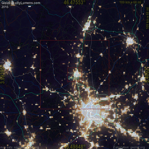
Analysis of Gleizé night lights 2016
Square area 10x10 km:
 8.1%
8.1%90-99
7.53%80-89
2.7%70-79
5.11%60-69
5.11%50-59
5.97%40-49
6.82%30-39
5.68%20-29
15.48%10-19
19.6%0-9
17.9%Square area 50x50 km:
3.06%90-99
2.81%80-89
1.23%70-79
1.65%60-69
1.8%50-59
2.5%40-49
2.93%30-39
3.42%20-29
5.35%10-19
7.44%0-9
67.81%Clear (daylight) street map image can be seen on geolist.org.
Map coordinates:
46° 28' 31.9" North, 3° 59' 38.2" East
45° 59' 21" North, 4° 41' 49.5" East
45° 29' 54.5" North, 5° 24' 0.7" East
Some cities around Gleizé sort by population:
• Villefranche-sur-Saône
1.7 km =1.1 mi,  88°
88°
• Neuville-sur-Saône
16.8 km =10.4 mi,  138°
138°
• Fontaines-sur-Saône
20.5 km =12.7 mi,  146°
146°
• Trévoux
7.7 km =4.8 mi,  131°
131°
• Belleville
13.9 km =8.6 mi,  16°
16°
• Jassans-Riottier
5 km =3.1 mi,  99°
99°
• Anse
6.2 km =3.9 mi,  163°
163°
• Lentilly
19.1 km =11.9 mi,  187°
187°
3015823 (p: 8,749)
Sources (retrieved 2019-11-25):
» Earth at Night: Flat Maps 2012, 2016