Champagnole night lights from space
Night Light of Champagnole (Bourgogne-Franche-Comté) from space (France) Src. Average luminocity for 10x10km area is 8.2813% and for 50x50km: 1.4681%.
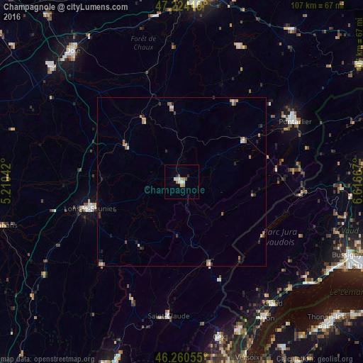
Analysis of Champagnole night lights 2016
Square area 10x10 km:
 1.49%
1.49%90-99
1.79%80-89
0.3%70-79
1.19%60-69
1.64%50-59
1.19%40-49
0.15%30-39
0.3%20-29
0.89%10-19
0%0-9
91.07%Square area 50x50 km:
0.12%90-99
0.21%80-89
0.12%70-79
0.21%60-69
0.36%50-59
0.19%40-49
0.17%30-39
0.22%20-29
0.35%10-19
0.2%0-9
97.84%Clear (daylight) street map image can be seen on geolist.org.
Map coordinates:
47° 13' 27.1" North, 5° 12' 37.5" East
46° 44' 40.3" North, 5° 54' 48.7" East
46° 15' 38" North, 6° 37' 0" East
Some cities around Champagnole sort by population:
• Lons-le-Saunier
28.3 km =17.6 mi,  254°
254°
• Pontarlier
38 km =23.6 mi,  62°
62°
• Valfin-lès-Saint-Claude
34.4 km =21.4 mi,  187°
187°
• Saint-Claude
40 km =24.9 mi, 185°
• Gland, CH
45.1 km =28 mi,  142°
142°
• Gex
47 km =29.2 mi,  166°
166°
• Divonne-les-Bains
46.3 km =28.8 mi,  158°
158°
• Morez
25.8 km =16 mi, 160°
3027235 (p: 9,239)
Sources (retrieved 2019-11-25):
» Earth at Night: Flat Maps 2012, 2016