Chagny night lights from space
Night Light of Chagny (Bourgogne-Franche-Comté) from space (France) Src. Average luminocity for 10x10km area is 4.8304% and for 50x50km: 5.0734%.
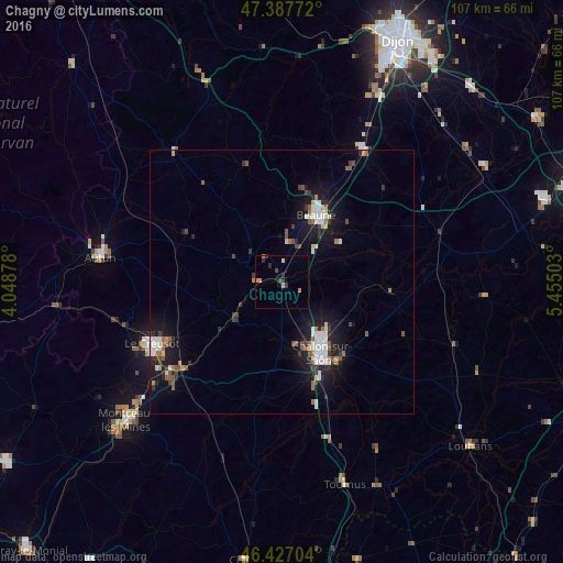
Analysis of Chagny night lights 2016
Square area 10x10 km:
 0%
0%90-99
0%80-89
0.6%70-79
1.64%60-69
1.04%50-59
0%40-49
1.04%30-39
0.3%20-29
3.13%10-19
0%0-9
92.26%Square area 50x50 km:
0.87%90-99
0.91%80-89
0.27%70-79
0.32%60-69
0.57%50-59
0.73%40-49
0.59%30-39
0.77%20-29
1.06%10-19
4.77%0-9
89.14%Clear (daylight) street map image can be seen on geolist.org.
Map coordinates:
47° 23' 15.8" North, 4° 2' 55.6" East
46° 54' 34.3" North, 4° 45' 6.8" East
46° 25' 37.3" North, 5° 27' 18.1" East
Some cities around Chagny sort by population:
• Chalon-sur-Saône
16.2 km =10.1 mi,  151°
151°
• Saint-Leu
27.6 km =17.1 mi,  223°
223°
• Le Creusot
27.9 km =17.3 mi,  245°
245°
• Beaune
14.3 km =8.9 mi,  27°
27°
• Châtenoy-le-Royal
13.2 km =8.2 mi,  159°
159°
• Saint-Rémy
17.6 km =10.9 mi, 157°
• Montchanin
27.8 km =17.3 mi,  230°
230°
• Nuits-Saint-Georges
29.4 km =18.3 mi, 30°
3027642 (p: 5,684)
Sources (retrieved 2019-11-25):
» Earth at Night: Flat Maps 2012, 2016