Nuits-Saint-Georges night lights from space
Night Light of Nuits-Saint-Georges (Bourgogne-Franche-Comté) from space (France) Src. Average luminocity for 10x10km area is 9.1435% and for 50x50km: 7.8728%.
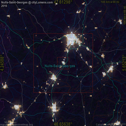
Analysis of Nuits-Saint-Georges night lights 2016
Square area 10x10 km:
 1.42%
1.42%90-99
1.7%80-89
0.85%70-79
0.43%60-69
1.28%50-59
1.85%40-49
0.43%30-39
1.14%20-29
1.42%10-19
0.43%0-9
89.06%Square area 50x50 km:
1.99%90-99
1.74%80-89
0.62%70-79
0.5%60-69
0.73%50-59
0.61%40-49
0.63%30-39
1.12%20-29
2%10-19
4.42%0-9
85.63%Clear (daylight) street map image can be seen on geolist.org.
Map coordinates:
47° 36' 46.7" North, 4° 14' 45.2" East
47° 8' 12.6" North, 4° 56' 56.4" East
46° 39' 23" North, 5° 39' 7.7" East
Some cities around Nuits-Saint-Georges sort by population:
• Dijon
20.6 km =12.8 mi,  14°
14°
• Beaune
15.1 km =9.4 mi,  213°
213°
• Chenôve
17.9 km =11.1 mi, 13°
• Talant
22.7 km =14.1 mi, 11°
• Chevigny-Saint-Sauveur
22.8 km =14.2 mi,  37°
37°
• Longvic
18.9 km =11.7 mi,  27°
27°
• Fontaine-lès-Dijon
23.5 km =14.6 mi, 13°
• Marsannay-la-Côte
15.2 km =9.4 mi, 11°
2989837 (p: 5,300)
Sources (retrieved 2019-11-25):
» Earth at Night: Flat Maps 2012, 2016