Carquefou night lights from space
Night Light of Carquefou (Pays de la Loire) from space (France) Src. Average luminocity for 10x10km area is 52.5238% and for 50x50km: 15.554%.
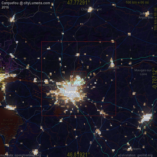
Analysis of Carquefou night lights 2016
Square area 10x10 km:
 14.73%
90-99
15.63%80-89
4.02%70-79
4.46%60-69
3.87%50-59
6.55%40-49
3.72%30-39
4.17%20-29
12.65%10-19
24.85%0-9
5.36%Square area 50x50 km:
3.86%90-99
3.04%80-89
1.16%70-79
1.56%60-69
1.88%50-59
1.93%40-49
1.9%30-39
1.82%20-29
3.69%10-19
6.78%0-9
72.38%Clear (daylight) street map image can be seen on geolist.org.
Map coordinates:
47° 46' 22.5" North, 2° 11' 36.1" West
47° 17' 53.6" North, 1° 29' 24.9" West
46° 49' 9.2" North, 0° 47' 13.6" West
Some cities around Carquefou sort by population:
• Nantes
10.2 km =6.3 mi,  207°
207°
• Saint-Sébastien-sur-Loire
10.1 km =6.3 mi,  185°
185°
• La Chapelle-sur-Erdre
4.7 km =2.9 mi,  266°
266°
• Sainte-Luce-sur-Loire
5 km =3.1 mi,  174°
174°
• Basse-Goulaine
9.8 km =6.1 mi, 169°
• Thouaré-sur-Loire
5.1 km =3.2 mi,  129°
129°
• Saint-Julien-de-Concelles
9.5 km =5.9 mi,  122°
122°
• Sucé-sur-Erdre
5.1 km =3.2 mi,  320°
320°
3028535 (p: 18,056)
Sources (retrieved 2019-11-25):
» Earth at Night: Flat Maps 2012, 2016