Brech night lights from space
Night Light of Brech (Brittany) from space (France) Src. Average luminocity for 10x10km area is 4.5952% and for 50x50km: 4.8776%.
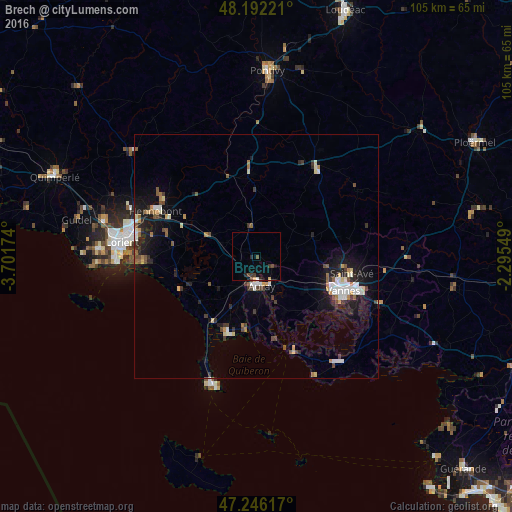
Analysis of Brech night lights 2016
Square area 10x10 km:
 0%
0%90-99
0.3%80-89
0.45%70-79
0.15%60-69
0%50-59
0.3%40-49
1.79%30-39
1.93%20-29
1.34%10-19
1.49%0-9
92.26%Square area 50x50 km:
0.53%90-99
0.93%80-89
0.42%70-79
0.43%60-69
0.52%50-59
0.58%40-49
0.67%30-39
0.74%20-29
1.19%10-19
3.75%0-9
90.25%Clear (daylight) street map image can be seen on geolist.org.
Map coordinates:
48° 11' 32" North, 3° 42' 6.3" West
47° 43' 16.8" North, 2° 59' 55" West
47° 14' 46.2" North, 2° 17' 43.8" West
Some cities around Brech sort by population:
• Vannes
19.5 km =12.1 mi,  111°
111°
• Hennebont
22.5 km =14 mi,  294°
294°
• Auray
5.7 km =3.5 mi,  174°
174°
• Saint-Avé
19.2 km =11.9 mi,  100°
100°
• Languidic
17.2 km =10.7 mi,  316°
316°
• Pluvigner
6.2 km =3.9 mi,  351°
351°
• Baud
17.1 km =10.6 mi,  355°
355°
• Arradon
16.9 km =10.5 mi,  128°
128°
3030440 (p: 5,071)
Sources (retrieved 2019-11-25):
» Earth at Night: Flat Maps 2012, 2016