Saint-Avé night lights from space
Night Light of Saint-Avé (Brittany) from space (France) Src. Average luminocity for 10x10km area is 35.1637% and for 50x50km: 3.5873%.
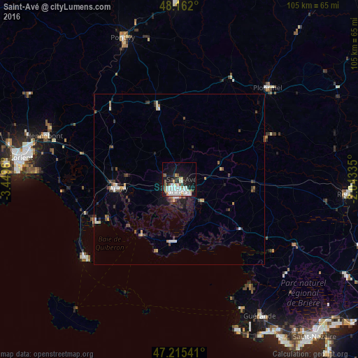
Analysis of Saint-Avé night lights 2016
Square area 10x10 km:
100  8.93%
8.93%
90-99 11.01%
80-89 2.68%
70-79 3.27%
60-69 1.93%
50-59 2.98%
40-49 1.34%
30-39 1.64%
20-29 6.85%
10-19 27.23%
0-9 32.14%
8.93%90-99
11.01%80-89
2.68%70-79
3.27%60-69
1.93%50-59
2.98%40-49
1.34%30-39
1.64%20-29
6.85%10-19
27.23%0-9
32.14%Square area 50x50 km:
100 0.5%
90-99 0.77%
80-89 0.27%
70-79 0.37%
60-69 0.27%
50-59 0.33%
40-49 0.54%
30-39 0.6%
20-29 0.73%
10-19 2.23%
0-9 93.38%
0.5%90-99
0.77%80-89
0.27%70-79
0.37%60-69
0.27%50-59
0.33%40-49
0.54%30-39
0.6%20-29
0.73%10-19
2.23%0-9
93.38%Clear (daylight) street map image can be seen on geolist.org.
Map coordinates:
48° 9' 43.2" North, 3° 26' 58.6" West
47° 41' 27.1" North, 2° 44' 47.3" West
47° 12' 55.5" North, 2° 2' 36.1" West
Some cities around Saint-Avé sort by population:
• Vannes
3.7 km =2.3 mi,  190°
190°
• Auray
18.5 km =11.5 mi,  262°
262°
• Séné
8 km =5 mi,  174°
174°
• Sarzeau
18.2 km =11.3 mi, 185°
• Pluvigner
21.9 km =13.6 mi,  295°
295°
• Theix
9.9 km =6.2 mi,  134°
134°
• Arradon
9 km =5.6 mi,  218°
218°
• Brech
19.2 km =11.9 mi,  280°
280°
2981515 (p: 8,907)
Sources (retrieved 2019-11-25):
» Earth at Night: Flat Maps 2012, 2016