Baud night lights from space
Night Light of Baud (Brittany) from space (France) Src. Average luminocity for 10x10km area is 2.0611% and for 50x50km: 4.6858%.
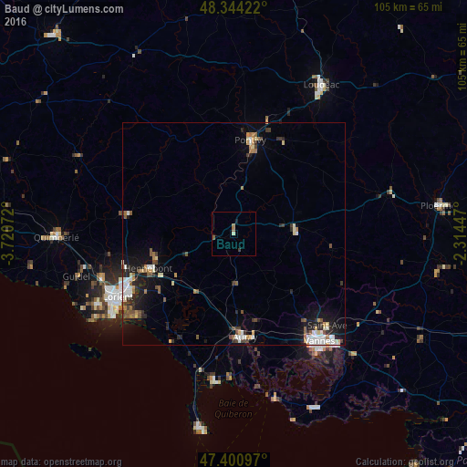
Analysis of Baud night lights 2016
Square area 10x10 km:
 0%
0%90-99
0.57%80-89
0%70-79
0%60-69
1.14%50-59
0.57%40-49
0.28%30-39
0.28%20-29
0%10-19
0.57%0-9
96.59%Square area 50x50 km:
0.66%90-99
0.92%80-89
0.41%70-79
0.44%60-69
0.57%50-59
0.64%40-49
0.57%30-39
0.69%20-29
1.14%10-19
3.02%0-9
90.96%Clear (daylight) street map image can be seen on geolist.org.
Map coordinates:
48° 20' 39.2" North, 3° 43' 14.6" West
47° 52' 29.1" North, 3° 1' 3.4" West
47° 24' 3.5" North, 2° 18' 52.1" West
Some cities around Baud sort by population:
• Pontivy
21.9 km =13.6 mi,  10°
10°
• Hennebont
20.6 km =12.8 mi,  247°
247°
• Auray
22.8 km =14.2 mi,  175°
175°
• Caudan
25.3 km =15.7 mi, 253°
• Languidic
11.5 km =7.1 mi, 245°
• Pluvigner
11 km =6.8 mi, 177°
• Plouay
24 km =14.9 mi,  280°
280°
• Brech
17.1 km =10.6 mi, 175°
3034582 (p: 5,206)
Sources (retrieved 2019-11-25):
» Earth at Night: Flat Maps 2012, 2016