Bourg-Saint-Maurice night lights from space
Night Light of Bourg-Saint-Maurice (Auvergne-Rhône-Alpes) from space (France) Src. Average luminocity for 10x10km area is 8.4182% and for 50x50km: 3.4756%.
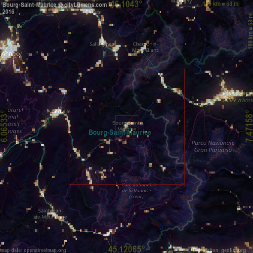
Analysis of Bourg-Saint-Maurice night lights 2016
Square area 10x10 km:
 0.3%
0.3%90-99
0.3%80-89
0.91%70-79
1.82%60-69
1.82%50-59
3.03%40-49
0.61%30-39
0%20-29
2.27%10-19
0.45%0-9
88.48%Square area 50x50 km:
0.14%90-99
0.41%80-89
0.46%70-79
0.58%60-69
0.59%50-59
0.57%40-49
0.48%30-39
0.32%20-29
0.72%10-19
0.52%0-9
95.2%Clear (daylight) street map image can be seen on geolist.org.
Map coordinates:
46° 6' 15.5" North, 6° 3' 55.2" East
45° 36' 52.7" North, 6° 46' 6.4" East
45° 7' 14.3" North, 7° 28' 17.7" East
Some cities around Bourg-Saint-Maurice sort by population:
• Albertville
30.1 km =18.7 mi,  282°
282°
• Sallanches
38.2 km =23.7 mi,  343°
343°
• Passy
34.8 km =21.6 mi,  350°
350°
• Chamonix-Mont-Blanc
35.3 km =21.9 mi,  12°
12°
• Ugine
31.6 km =19.6 mi,  299°
299°
• Faverges
40 km =24.9 mi,  292°
292°
• Saint-Gervais-les-Bains
31 km =19.3 mi, 352°
• Megève
29.4 km =18.3 mi, 336°
3030949 (p: 8,114)
Sources (retrieved 2019-11-25):
» Earth at Night: Flat Maps 2012, 2016