Albertville night lights from space
Night Light of Albertville (Auvergne-Rhône-Alpes) from space (France) Src. Average luminocity for 10x10km area is 24.2545% and for 50x50km: 5.7026%.
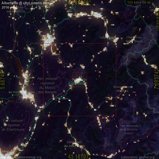
Analysis of Albertville night lights 2016
Square area 10x10 km:
 4.39%
4.39%90-99
5.3%80-89
0.3%70-79
3.48%60-69
2.73%50-59
2.58%40-49
1.97%30-39
1.97%20-29
0.3%10-19
35.91%0-9
41.06%Square area 50x50 km:
0.51%90-99
0.81%80-89
0.48%70-79
0.7%60-69
0.79%50-59
0.96%40-49
0.84%30-39
0.76%20-29
1.24%10-19
3.12%0-9
89.79%Clear (daylight) street map image can be seen on geolist.org.
Map coordinates:
46° 9' 49.2" North, 5° 41' 15" East
45° 40' 28.3" North, 6° 23' 26.2" East
45° 10' 51.9" North, 7° 5' 37.5" East
Some cities around Albertville sort by population:
• Annecy
33.2 km =20.6 mi,  321°
321°
• Seynod
33.2 km =20.6 mi, 315°
• Bourg-Saint-Maurice
30.1 km =18.7 mi,  102°
102°
• Ugine
9.2 km =5.7 mi,  11°
11°
• Faverges
11.5 km =7.1 mi, 317°
• Thônes
23.5 km =14.6 mi,  347°
347°
• Saint-Jorioz
25.1 km =15.6 mi,  313°
313°
• Megève
26.9 km =16.7 mi,  40°
40°
3038266 (p: 19,113)
Sources (retrieved 2019-11-25):
» Earth at Night: Flat Maps 2012, 2016