Faverges night lights from space
Night Light of Faverges (Auvergne-Rhône-Alpes) from space (France) Src. Average luminocity for 10x10km area is 6.4905% and for 50x50km: 7.7934%.
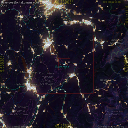
Analysis of Faverges night lights 2016
Square area 10x10 km:
 0.48%
0.48%90-99
0.79%80-89
0%70-79
0.63%60-69
2.54%50-59
0.63%40-49
1.9%30-39
1.27%20-29
0.63%10-19
0%0-9
91.11%Square area 50x50 km:
0.98%90-99
1.37%80-89
0.67%70-79
0.8%60-69
1.01%50-59
1.02%40-49
1%30-39
1.04%20-29
2.05%10-19
5.26%0-9
84.82%Clear (daylight) street map image can be seen on geolist.org.
Map coordinates:
46° 14' 22.7" North, 5° 35' 18.2" East
45° 45' 4.2" North, 6° 17' 29.4" East
45° 15' 30.2" North, 6° 59' 40.7" East
Some cities around Faverges sort by population:
• Annecy
21.7 km =13.5 mi,  323°
323°
• Annecy-le-Vieux
22 km =13.7 mi,  328°
328°
• Cran-Gevrier
22.2 km =13.8 mi, 318°
• Albertville
11.5 km =7.1 mi,  137°
137°
• Seynod
21.7 km =13.5 mi,  313°
313°
• Ugine
9.6 km =6 mi,  86°
86°
• Thônes
14.7 km =9.1 mi,  10°
10°
• Saint-Jorioz
13.6 km =8.5 mi, 310°
3018903 (p: 6,580)
Sources (retrieved 2019-11-25):
» Earth at Night: Flat Maps 2012, 2016