Bernay night lights from space
Night Light of Bernay (Normandy) from space (France) Src. Average luminocity for 10x10km area is 6.2101% and for 50x50km: 1.7886%.
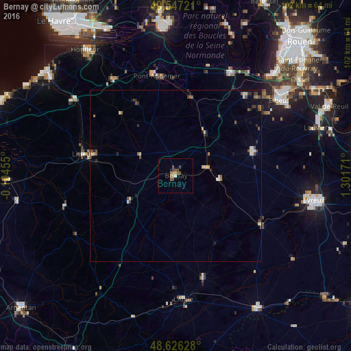
Analysis of Bernay night lights 2016
Square area 10x10 km:
 0.28%
0.28%90-99
0.28%80-89
0.42%70-79
1.68%60-69
0.56%50-59
2.38%40-49
1.82%30-39
0.98%20-29
0.56%10-19
0%0-9
91.04%Square area 50x50 km:
0.11%90-99
0.35%80-89
0.18%70-79
0.15%60-69
0.18%50-59
0.43%40-49
0.39%30-39
0.33%20-29
0.27%10-19
0.4%0-9
97.21%Clear (daylight) street map image can be seen on geolist.org.
Map coordinates:
49° 32' 50" North, 0° 6' 16.4" West
49° 5' 20" North, 0° 35' 54.9" East
48° 37' 34.6" North, 1° 18' 6.2" East
Some cities around Bernay sort by population:
• Évreux
40.9 km =25.4 mi,  100°
100°
• Lisieux
27.6 km =17.1 mi,  283°
283°
• Elbeuf
36.7 km =22.8 mi,  53°
53°
• Caudebec-lès-Elbeuf
37.4 km =23.2 mi,  55°
55°
• Pont-Audemer
29.6 km =18.4 mi,  348°
348°
• Saint-Pierre-lès-Elbeuf
38.6 km =24 mi, 56°
• Saint-Aubin-lès-Elbeuf
38.3 km =23.8 mi, 51°
• Cléon
40 km =24.9 mi, 51°
3033308 (p: 12,399)
Sources (retrieved 2019-11-25):
» Earth at Night: Flat Maps 2012, 2016