Pont-Audemer night lights from space
Night Light of Pont-Audemer (Normandy) from space (France) Src. Average luminocity for 10x10km area is 6.1257% and for 50x50km: 8.8206%.
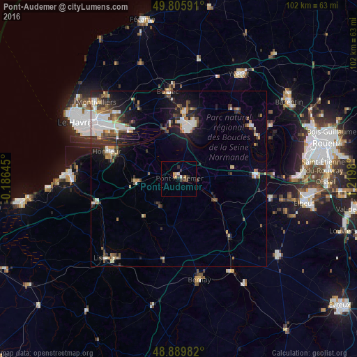
Analysis of Pont-Audemer night lights 2016
Square area 10x10 km:
 0.27%
0.27%90-99
0.27%80-89
1.2%70-79
1.2%60-69
0.8%50-59
0%40-49
1.74%30-39
2.54%20-29
1.47%10-19
0.13%0-9
90.37%Square area 50x50 km:
1.78%90-99
1.53%80-89
0.76%70-79
0.73%60-69
0.94%50-59
1.18%40-49
1.08%30-39
1.66%20-29
2.22%10-19
4.43%0-9
83.66%Clear (daylight) street map image can be seen on geolist.org.
Map coordinates:
49° 48' 21.3" North, 0° 11' 11.2" West
49° 21' 0" North, 0° 31' 0" East
48° 53' 23.4" North, 1° 13' 11.3" East
Some cities around Pont-Audemer sort by population:
• Lisieux
30.8 km =19.1 mi,  222°
222°
• Bolbec
25 km =15.5 mi,  352°
352°
• Bernay
29.6 km =18.4 mi,  168°
168°
• Lillebonne
19 km =11.8 mi,  4°
4°
• Notre-Dame-de-Gravenchon
16 km =9.9 mi,  14°
14°
• Harfleur
28.9 km =18 mi,  307°
307°
• Honfleur
22 km =13.7 mi,  290°
290°
• Le Trait
25.4 km =15.8 mi,  58°
58°
2986294 (p: 9,666)
Sources (retrieved 2019-11-25):
» Earth at Night: Flat Maps 2012, 2016