Lisses night lights from space
Night Light of Lisses (Île-de-France) from space (France) Src. Average luminocity for 10x10km area is 76.7515% and for 50x50km: 45.1859%.
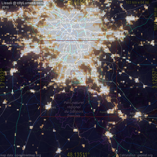
Analysis of Lisses night lights 2016
Square area 10x10 km:
 29.32%
90-99
26.04%80-89
3.87%70-79
7.29%60-69
5.8%50-59
3.27%40-49
5.95%30-39
7.44%20-29
9.97%10-19
1.04%0-9
0%Square area 50x50 km:
16.08%90-99
10.98%80-89
3.37%70-79
3.94%60-69
4.75%50-59
3.66%40-49
4.57%30-39
4.79%20-29
6.34%10-19
11.49%0-9
30.03%Clear (daylight) street map image can be seen on geolist.org.
Map coordinates:
49° 3' 54.2" North, 1° 43' 9.6" East
48° 36' 8" North, 2° 25' 20.8" East
48° 8' 6.4" North, 3° 7' 32.1" East
Some cities around Lisses sort by population:
• Évry
3.6 km =2.2 mi,  21°
21°
• Corbeil-Essonnes
4.8 km =3 mi,  84°
84°
• Courcouronnes
1.7 km =1.1 mi,  320°
320°
• Mennecy
4 km =2.5 mi,  156°
156°
• Bondoufle
3.5 km =2.2 mi,  289°
289°
• Saint-Germain-lès-Corbeil
5.3 km =3.3 mi,  65°
65°
• Saint-Pierre-du-Perray
5.4 km =3.4 mi, 79°
• Villabé
2.5 km =1.6 mi,  124°
124°
2998105 (p: 7,601)
Sources (retrieved 2019-11-25):
» Earth at Night: Flat Maps 2012, 2016