Pignan night lights from space
Night Light of Pignan (Occitanie) from space (France) Src. Average luminocity for 10x10km area is 44.0955% and for 50x50km: 20.6549%.
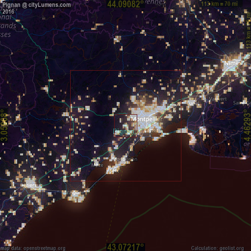
Analysis of Pignan night lights 2016
Square area 10x10 km:
 7.27%
7.27%90-99
10.45%80-89
5.3%70-79
3.33%60-69
6.82%50-59
3.79%40-49
3.79%30-39
10.61%20-29
15.45%10-19
27.58%0-9
5.61%Square area 50x50 km:
3.87%90-99
4.51%80-89
2.11%70-79
2.02%60-69
2.25%50-59
1.57%40-49
1.69%30-39
2.72%20-29
6.37%10-19
16.31%0-9
56.58%Clear (daylight) street map image can be seen on geolist.org.
Map coordinates:
44° 5' 27" North, 3° 3' 24" East
43° 35' 1.1" North, 3° 45' 35.3" East
43° 4' 19.8" North, 4° 27' 46.5" East
Some cities around Pignan sort by population:
• Montpellier
9.9 km =6.2 mi,  72°
72°
• Lattes
11.8 km =7.3 mi,  98°
98°
• Saint-Jean-de-Védas
5.4 km =3.4 mi, 97°
• Villeneuve-lès-Maguelone
10.3 km =6.4 mi,  123°
123°
• Fabrègues
3.9 km =2.4 mi,  160°
160°
• Juvignac
5.3 km =3.3 mi,  50°
50°
• Grabels
7.8 km =4.8 mi,  23°
23°
• Cournonterral
4.2 km =2.6 mi,  229°
229°
2987180 (p: 6,348)
Sources (retrieved 2019-11-25):
» Earth at Night: Flat Maps 2012, 2016