Ancenis night lights from space
Night Light of Ancenis (Pays de la Loire) from space (France) Src. Average luminocity for 10x10km area is 13.0387% and for 50x50km: 4.833%.
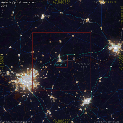
Analysis of Ancenis night lights 2016
Square area 10x10 km:
 1.64%
1.64%90-99
2.08%80-89
2.83%70-79
1.93%60-69
0.45%50-59
1.34%40-49
1.49%30-39
1.49%20-29
0.74%10-19
4.32%0-9
81.7%Square area 50x50 km:
0.64%90-99
0.81%80-89
0.48%70-79
0.52%60-69
0.73%50-59
0.89%40-49
0.76%30-39
0.75%20-29
1.12%10-19
2.04%0-9
91.26%Clear (daylight) street map image can be seen on geolist.org.
Map coordinates:
47° 50' 26.7" North, 1° 52' 11.3" West
47° 22' 0" North, 1° 10' 0" West
46° 53' 17.8" North, 0° 27' 48.8" West
Some cities around Ancenis sort by population:
• Carquefou
25.5 km =15.8 mi,  252°
252°
• Sainte-Luce-sur-Loire
27 km =16.8 mi,  242°
242°
• Vallet
23.9 km =14.9 mi,  198°
198°
• Thouaré-sur-Loire
23.2 km =14.4 mi, 242°
• Beaupréau
22.5 km =14 mi,  143°
143°
• Saint-Julien-de-Concelles
20.7 km =12.9 mi,  232°
232°
• Nort-sur-Erdre
26.2 km =16.3 mi,  287°
287°
• Le Loroux-Bottereau
19.9 km =12.4 mi,  223°
223°
3037797 (p: 7,840)
Sources (retrieved 2019-11-25):
» Earth at Night: Flat Maps 2012, 2016