Mänttä night lights from space
Night Light of Mänttä (Pirkanmaa) from space (Finland) Src. Average luminocity for 10x10km area is 8.666% and for 50x50km: 0.8956%.
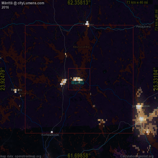
Analysis of Mänttä night lights 2016
Square area 10x10 km:
 1.19%
1.19%90-99
1.28%80-89
0.69%70-79
1.58%60-69
0.89%50-59
2.17%40-49
0.1%30-39
0%20-29
0.4%10-19
1.28%0-9
90.42%Square area 50x50 km:
0.14%90-99
0.11%80-89
0.06%70-79
0.1%60-69
0.17%50-59
0.15%40-49
0.14%30-39
0.1%20-29
0.02%10-19
0.05%0-9
98.97%Clear (daylight) street map image can be seen on geolist.org.
Map coordinates:
62° 21' 29.3" North, 23° 55' 29.2" East
62° 1' 48.5" North, 24° 37' 40.5" East
61° 41' 54.9" North, 25° 19' 51.7" East
Some cities around Mänttä sort by population:
• Jämsä
34.7 km =21.6 mi,  122°
122°
• Keuruu
26.6 km =16.5 mi,  8°
8°
• Orivesi
41.7 km =25.9 mi,  199°
199°
• Virrat
50.3 km =31.3 mi,  298°
298°
• Jämsänkoski
30.9 km =19.2 mi,  113°
113°
• Vilppula
6.5 km =4 mi,  261°
261°
• Ruovesi
30.2 km =18.8 mi, 260°
• Korpilahti
48.1 km =29.9 mi,  91°
91°
646705 (p: 6,459)
Sources (retrieved 2019-11-25):
» Earth at Night: Flat Maps 2012, 2016