Jämsänkoski night lights from space
Night Light of Jämsänkoski (Central Finland) from space (Finland) Src. Average luminocity for 10x10km area is 21.4741% and for 50x50km: 4.2532%.
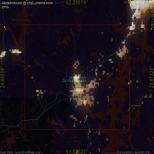
Analysis of Jämsänkoski night lights 2016
Square area 10x10 km:
 1.35%
1.35%90-99
1.55%80-89
1.86%70-79
3.42%60-69
8.28%50-59
2.9%40-49
1.45%30-39
0.21%20-29
7.87%10-19
26.4%0-9
44.72%Square area 50x50 km:
0.1%90-99
0.15%80-89
0.16%70-79
0.4%60-69
0.88%50-59
1.58%40-49
1.57%30-39
1.09%20-29
0.93%10-19
2.74%0-9
90.39%Clear (daylight) street map image can be seen on geolist.org.
Map coordinates:
62° 14' 53.5" North, 24° 28' 1.2" East
61° 55' 8.4" North, 25° 10' 12.4" East
61° 35' 10.4" North, 25° 52' 23.7" East
Some cities around Jämsänkoski sort by population:
• Jyväskylä
45.9 km =28.5 mi,  38°
38°
• Keuruu
45.7 km =28.4 mi,  327°
327°
• Orivesi
50.4 km =31.3 mi,  237°
237°
• Muurame
35.2 km =21.9 mi,  47°
47°
• Mänttä
30.9 km =19.2 mi,  293°
293°
• Vilppula
36.6 km =22.7 mi, 288°
• Ruovesi
58.7 km =36.5 mi,  277°
277°
• Korpilahti
22.6 km =14 mi,  61°
61°
656076 (p: 7,442)
Sources (retrieved 2019-11-25):
» Earth at Night: Flat Maps 2012, 2016