Korpilahti night lights from space
Night Light of Korpilahti (Central Finland) from space (Finland) Src. Average luminocity for 10x10km area is 12.2184% and for 50x50km: 7.7068%.
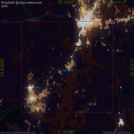
Analysis of Korpilahti night lights 2016
Square area 10x10 km:
 0%
0%90-99
0%80-89
0.1%70-79
0.89%60-69
1.48%50-59
10.57%40-49
3.95%30-39
0.79%20-29
0%10-19
4.25%0-9
77.96%Square area 50x50 km:
0.8%90-99
0.87%80-89
0.41%70-79
0.85%60-69
1.53%50-59
1.98%40-49
1.92%30-39
1.23%20-29
2.09%10-19
4.65%0-9
83.66%Clear (daylight) street map image can be seen on geolist.org.
Map coordinates:
62° 20' 41.3" North, 24° 50' 48.8" East
62° 1' 0" North, 25° 33' 0" East
61° 41' 5.9" North, 26° 15' 11.3" East
Some cities around Korpilahti sort by population:
• Jyväskylä
26.5 km =16.5 mi,  19°
19°
• Laukaa
48.9 km =30.4 mi,  25°
25°
• Jämsä
25.3 km =15.7 mi,  227°
227°
• Keuruu
52.2 km =32.4 mi,  302°
302°
• Muurame
14.3 km =8.9 mi, 25°
• Jämsänkoski
22.6 km =14 mi,  241°
241°
• Mänttä
48.1 km =29.9 mi,  271°
271°
• Vilppula
54.5 km =33.9 mi, 270°
651350 (p: 5,050)
Sources (retrieved 2019-11-25):
» Earth at Night: Flat Maps 2012, 2016