Vilaseca night lights from space
Night Light of Vilaseca (Catalonia) from space (Spain) Src. Average luminocity for 10x10km area is 19.3952% and for 50x50km: 5.8243%.
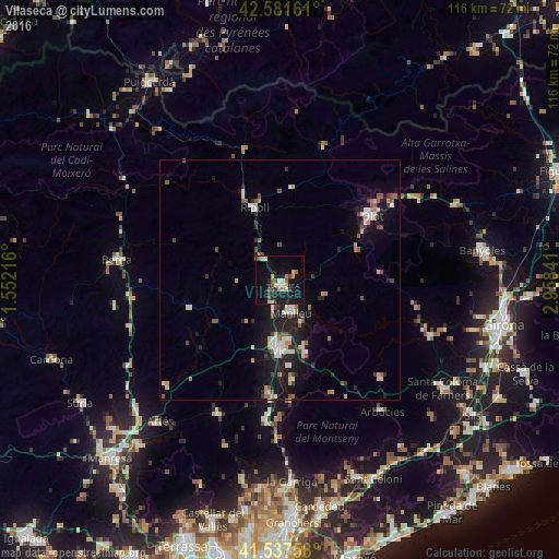
Analysis of Vilaseca night lights 2016
Square area 10x10 km:
 1.59%
1.59%90-99
3.65%80-89
0.63%70-79
3.02%60-69
1.75%50-59
3.81%40-49
2.7%30-39
0.95%20-29
3.17%10-19
24.44%0-9
54.29%Square area 50x50 km:
0.66%90-99
0.92%80-89
0.6%70-79
0.58%60-69
0.55%50-59
0.89%40-49
0.8%30-39
0.64%20-29
1.43%10-19
5.42%0-9
87.51%Clear (daylight) street map image can be seen on geolist.org.
Map coordinates:
42° 34' 53.8" North, 1° 33' 7.8" East
42° 3' 42.3" North, 2° 15' 19" East
41° 32' 15.3" North, 2° 57' 30.3" East
Some cities around Vilaseca sort by population:
• Vic
14.6 km =9.1 mi,  180°
180°
• Olot
23.5 km =14.6 mi,  55°
55°
• Manlleu
7 km =4.3 mi,  159°
159°
• Torelló
2 km =1.2 mi,  151°
151°
• Ripoll
16.3 km =10.1 mi,  340°
340°
• Sant Cristòfol de les Fonts
23.4 km =14.5 mi, 59°
• Tona
23.9 km =14.9 mi,  185°
185°
• Taradell
20.9 km =13 mi,  172°
172°
3105805 (p: 17,305)
Sources (retrieved 2019-11-25):
» Earth at Night: Flat Maps 2012, 2016