Torelló night lights from space
Night Light of Torelló (Catalonia) from space (Spain) Src. Average luminocity for 10x10km area is 23.573% and for 50x50km: 6.0527%.
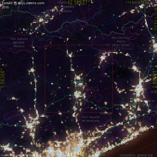
Analysis of Torelló night lights 2016
Square area 10x10 km:
 3.49%
3.49%90-99
4.6%80-89
0.95%70-79
3.02%60-69
2.7%50-59
2.86%40-49
2.7%30-39
1.9%20-29
3.17%10-19
31.75%0-9
42.86%Square area 50x50 km:
0.68%90-99
0.95%80-89
0.62%70-79
0.58%60-69
0.55%50-59
0.94%40-49
0.84%30-39
0.7%20-29
1.47%10-19
5.77%0-9
86.89%Clear (daylight) street map image can be seen on geolist.org.
Map coordinates:
42° 33' 58.6" North, 1° 33' 49.2" East
42° 2' 46.6" North, 2° 16' 0.4" East
41° 31' 19.1" North, 2° 58' 11.7" East
Some cities around Torelló sort by population:
• Vic
13 km =8.1 mi,  184°
184°
• Olot
23.7 km =14.7 mi,  50°
50°
• Manlleu
5.1 km =3.2 mi,  163°
163°
• Vilaseca
2 km =1.2 mi,  331°
331°
• Ripoll
18.3 km =11.4 mi,  339°
339°
• Sant Cristòfol de les Fonts
23.6 km =14.7 mi, 54°
• Tona
22.3 km =13.9 mi,  188°
188°
• Taradell
19.1 km =11.9 mi, 175°
3107941 (p: 13,808)
Sources (retrieved 2019-11-25):
» Earth at Night: Flat Maps 2012, 2016