Cuntis night lights from space
Night Light of Cuntis (Galicia) from space (Spain) Src. Average luminocity for 10x10km area is 7.9606% and for 50x50km: 19.3718%.
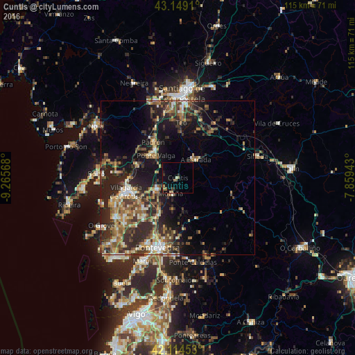
Analysis of Cuntis night lights 2016
Square area 10x10 km:
 0%
0%90-99
0.3%80-89
1.52%70-79
0.61%60-69
1.67%50-59
1.06%40-49
0.91%30-39
0.91%20-29
1.52%10-19
8.03%0-9
83.48%Square area 50x50 km:
1.2%90-99
3.11%80-89
2.18%70-79
2.47%60-69
3.32%50-59
3.48%40-49
3.27%30-39
4.43%20-29
7.88%10-19
11.68%0-9
56.98%Clear (daylight) street map image can be seen on geolist.org.
Map coordinates:
43° 8' 56.8" North, 9° 15' 56.4" West
42° 38' 2.3" North, 8° 33' 45.2" West
42° 6' 52.3" North, 7° 51' 33.9" West
Some cities around Cuntis sort by population:
• Vilagarcía de Arousa
17 km =10.6 mi,  255°
255°
• Ribeira
15.8 km =9.8 mi,  37°
37°
• A Estrada
8.6 km =5.3 mi, 44°
• Teo
13.9 km =8.6 mi,  21°
21°
• Caldas de Reis
7.3 km =4.5 mi,  243°
243°
• Padrón
14.1 km =8.8 mi,  325°
325°
• Valga
9.5 km =5.9 mi,  318°
318°
• Vedra
17.5 km =10.9 mi, 23°
3124021 (p: 5,398)
Sources (retrieved 2019-11-25):
» Earth at Night: Flat Maps 2012, 2016