Santanyí night lights from space
Night Light of Santanyí (Balearic Islands) from space (Spain) Src. Average luminocity for 10x10km area is 3.9473% and for 50x50km: 2.8033%.
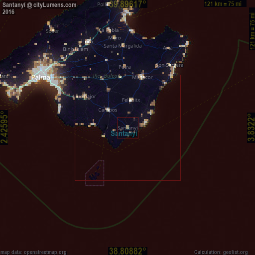
Analysis of Santanyí night lights 2016
Square area 10x10 km:
 0%
0%90-99
0%80-89
0%70-79
0.34%60-69
0.34%50-59
2.04%40-49
1.36%30-39
1.02%20-29
1.7%10-19
0.68%0-9
92.52%Square area 50x50 km:
0.14%90-99
0.34%80-89
0.47%70-79
0.23%60-69
0.27%50-59
0.72%40-49
0.47%30-39
0.59%20-29
0.43%10-19
0.33%0-9
96.01%Clear (daylight) street map image can be seen on geolist.org.
Map coordinates:
39° 53' 46.2" North, 2° 25' 33.4" East
39° 21' 16.6" North, 3° 7' 44.7" East
38° 48' 31.8" North, 3° 49' 55.9" East
Some cities around Santanyí sort by population:
• Manacor
24.9 km =15.5 mi,  16°
16°
• Llucmajor
25.4 km =15.8 mi,  306°
306°
• Felanitx
12.9 km =8 mi,  7°
7°
• Son Servera
35.6 km =22.1 mi,  33°
33°
• s'Arenal
36.3 km =22.6 mi,  296°
296°
• Campos
12.7 km =7.9 mi, 312°
• Porto Cristo
27 km =16.8 mi,  40°
40°
• Can Pastilla
40.7 km =25.3 mi, 299°
2511106 (p: 12,664)
Sources (retrieved 2019-11-25):
» Earth at Night: Flat Maps 2012, 2016