Felanitx night lights from space
Night Light of Felanitx (Balearic Islands) from space (Spain) Src. Average luminocity for 10x10km area is 4.4422% and for 50x50km: 3.8517%.
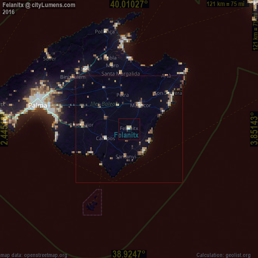
Analysis of Felanitx night lights 2016
Square area 10x10 km:
 0.34%
0.34%90-99
1.02%80-89
1.7%70-79
0.34%60-69
0%50-59
0%40-49
0.68%30-39
0.17%20-29
0.51%10-19
0%0-9
95.24%Square area 50x50 km:
0.16%90-99
0.47%80-89
0.6%70-79
0.29%60-69
0.45%50-59
0.9%40-49
0.7%30-39
0.79%20-29
0.5%10-19
0.67%0-9
94.47%Clear (daylight) street map image can be seen on geolist.org.
Map coordinates:
40° 0' 37" North, 2° 26' 42.6" East
39° 28' 10.6" North, 3° 8' 53.9" East
38° 55' 28.9" North, 3° 51' 5.1" East
Some cities around Felanitx sort by population:
• Manacor
12.3 km =7.6 mi,  25°
25°
• Llucmajor
22.2 km =13.8 mi,  276°
276°
• Santanyí
12.9 km =8 mi,  187°
187°
• Son Servera
24.7 km =15.3 mi,  47°
47°
• Santa Margalida
26.1 km =16.2 mi,  351°
351°
• Campos
11.9 km =7.4 mi,  248°
248°
• Porto Cristo
17.7 km =11 mi,  63°
63°
• Artà
30.3 km =18.8 mi, 34°
2517750 (p: 18,270)
Sources (retrieved 2019-11-25):
» Earth at Night: Flat Maps 2012, 2016