Can Pastilla night lights from space
Night Light of Can Pastilla (Balearic Islands) from space (Spain) Src. Average luminocity for 10x10km area is 54.8831% and for 50x50km: 12.3455%.
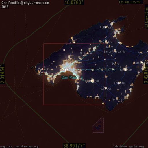
Analysis of Can Pastilla night lights 2016
Square area 10x10 km:
 16.23%
90-99
12.99%80-89
4.38%70-79
4.22%60-69
5.19%50-59
6.98%40-49
4.06%30-39
10.88%20-29
17.69%10-19
12.82%0-9
4.55%Square area 50x50 km:
1.95%90-99
2.02%80-89
1.52%70-79
1.12%60-69
1.64%50-59
2.03%40-49
1.17%30-39
1.76%20-29
3.46%10-19
8.23%0-9
75.1%Clear (daylight) street map image can be seen on geolist.org.
Map coordinates:
40° 4' 34.7" North, 2° 0' 52.3" East
39° 32' 10.1" North, 2° 43' 3.6" East
38° 59' 30.4" North, 3° 25' 14.8" East
Some cities around Can Pastilla sort by population:
• Palma
6.9 km =4.3 mi,  302°
302°
• Llucmajor
15.7 km =9.8 mi,  108°
108°
• Marratxí
9.5 km =5.9 mi,  3°
3°
• Coll d'en Rabassa
2.6 km =1.6 mi,  309°
309°
• s'Arenal
4.9 km =3 mi,  145°
145°
• Es Molinar
4.6 km =2.9 mi, 307°
• Palmanova
15.4 km =9.6 mi,  265°
265°
• Bunyola
17.9 km =11.1 mi,  355°
355°
6355016 (p: 5,390)
Sources (retrieved 2019-11-25):
» Earth at Night: Flat Maps 2012, 2016