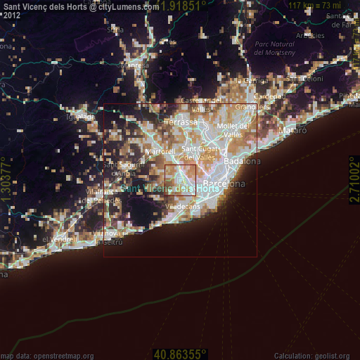
Sant Vicenç dels Horts night lights from space
Night Light of Sant Vicenç dels Horts (Catalonia) from space (Spain) Src. Average luminocity for 10x10km area is 77.1037% and for 50x50km: 45.9699%.
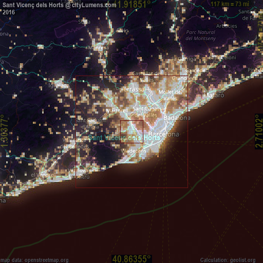
Analysis of Sant Vicenç dels Horts night lights 2016
Square area 10x10 km:
 17.35%
90-99
17.86%80-89
9.69%70-79
12.93%60-69
26.19%50-59
10.54%40-49
1.7%30-39
3.74%20-29
0%10-19
0%0-9
0%Square area 50x50 km:
11.46%90-99
10.47%80-89
4.74%70-79
5.56%60-69
7.84%50-59
6.35%40-49
3.7%30-39
4.09%20-29
9.71%10-19
12.42%0-9
23.67%Clear (daylight) street map image can be seen on geolist.org.
Map coordinates:
41° 55' 6.6" North, 1° 18' 13.6" East
41° 23' 35.4" North, 2° 0' 24.8" East
40° 51' 48.8" North, 2° 42' 36.1" East
Some cities around Sant Vicenç dels Horts sort by population:
• Cornellà de Llobregat
8 km =5 mi,  126°
126°
• Esplugues de Llobregat
7 km =4.3 mi,  104°
104°
• Molins de Rei
2.7 km =1.7 mi,  17°
17°
• Vallirana
6.3 km =3.9 mi,  263°
263°
• Corbera de Llobregat
7.7 km =4.8 mi,  290°
290°
• Pallejà
3.6 km =2.2 mi,  343°
343°
• Cervelló
4 km =2.5 mi,  274°
274°
• Santa Coloma de Cervelló
2.9 km =1.8 mi,  167°
167°
3109442 (p: 27,701)
Sources (retrieved 2019-11-25):
» Earth at Night: Flat Maps 2012, 2016