Villaviciosa night lights from space
Night Light of Villaviciosa (Asturias) from space (Spain) Src. Average luminocity for 10x10km area is 10.3413% and for 50x50km: 8.9315%.
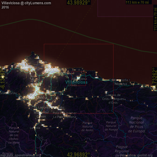
Analysis of Villaviciosa night lights 2016
Square area 10x10 km:
 1.43%
1.43%90-99
1.11%80-89
0.63%70-79
0%60-69
1.27%50-59
1.59%40-49
0.95%30-39
3.65%20-29
4.6%10-19
1.9%0-9
82.86%Square area 50x50 km:
1.42%90-99
1.62%80-89
0.47%70-79
0.66%60-69
0.63%50-59
1.83%40-49
0.94%30-39
1.79%20-29
3.7%10-19
7.45%0-9
79.48%Clear (daylight) street map image can be seen on geolist.org.
Map coordinates:
43° 59' 21.4" North, 6° 8' 19.9" West
43° 28' 52.5" North, 5° 26' 8.7" West
42° 58' 8.1" North, 4° 43' 57.4" West
Some cities around Villaviciosa sort by population:
• Gijón
19.2 km =11.9 mi,  288°
288°
• Natahoyo
20.9 km =13 mi, 288°
• Pola de Laviana
28.2 km =17.5 mi,  201°
201°
• Pola de Siero
20.9 km =13 mi,  241°
241°
• Piloña
15.6 km =9.7 mi,  159°
159°
• El entrego
27 km =16.8 mi,  217°
217°
• Cangas de Onís
28.7 km =17.8 mi,  120°
120°
• Parres
27.3 km =17 mi, 122°
3104707 (p: 14,775)
Sources (retrieved 2019-11-25):
» Earth at Night: Flat Maps 2012, 2016